
Early History
The first people to live in the Matanuska Valley, where Palmer is located, were the Dena’ina and Ahtna Athabaskans. In May of 1893, Alaska pioneer George Palmer (born in Pennsylvania) made his way to Alaska from Seattle where he was a logger. Mr. Palmer was a rugged entrepreneur with a history of doing business around the Matanuska valley which included growing the first vegetables, the first privately owned stores, and the first appointed U.S. postmaster in Knik in October of 1904. Mr. Palmer also brought the first hay reaper into the area, started selling farm equipment, renting horse teams, and established trading posts to trade and supply the people of the area with food, goods, mail, fur, etc.
The townsite of Palmer served as a gateway to the Alaska interior for fur traders, trappers, gold miners, and those wanting to live life on the frontier.
Palmer also served as a homesteading area for miners who had returned from the Nelchina gold stampede in 1913 to lead an agricultural lifestyle. Development of the coal mines north of Palmer, Eska, and Chickaloon, and the influx of gold miners heading to Independence Mine in Hatcher Pass contributed to the increase in population.
In 1914, John Bugge, Roy Cornelius, John Loken, Adam Werner, and Ed Duncklee came by steamship together as the first homesteaders in the Palmer area. Mr. Bugge started a farm where the Palmer-Wasilla Highway and Glenn Highway intersect. The Werner homestead, a Centennail Farm, located north of downtown Palmer, is a testimony to Adam and Fanny Werner’s skill and hard work.
In the late 19th century, the U.S. government began to take interest in the Matanuska coal fields located north of Palmer. This interest sparked financiers to consider constructing the Alaska Central Railroad in 1904. The advent of World War I created a need for high-quality coal to fuel U.S. battleships, and by 1917 the US Navy had constructed rail from the port of Seward to the Chickaloon coal deposits. At the end of WWI, the U.S. Navy distributed land in the coal fields to war veterans and additional land was opened for homesteading. Farmers, miners, and homesteaders began to populate the area.
The Palmer Post Office opened July 6, 1917, with Georen O. White as postmaster. In 1925 the Post Office was abandoned by Mr. White. Mr. Ward and Mr. Felton petitioned Washington for the post office to reopen but the government declined their request. They then petitioned to open the post office using a combination of their names. The petition was accepted, and James W. Felton was appointed postmaster of the Warton Post Office on July 13, 1931. On July 1, 1935, the post office returned to the name of Palmer with James W. Felton continuing as postmaster.
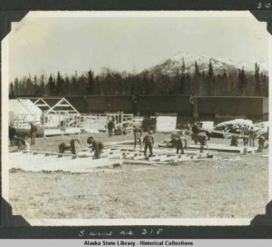
With railroad accessibility, new markets for agriculture began to open up for farmers in the Matanuska Valley. Although the Federal Department of Agriculture broke ground on the experiment station in 1917, Palmer didn’t become a bustling community until the Colonist families arrived in 1935. In one year, Palmer transformed from a mere whistle-stop rail siding to a planned community with modern utilities and community services.
Our townsite was designed in 1935 during the Great Depression as one of the 100 planned FDR New Deal “resettlement communities”. In May of that year, 203 families from Michigan, Minnesota, and Wisconsin were relocated to the Matanuska Valley to develop an agricultural community in what was then a Territory. There is much documentation about this time in Palmer’s history.
Many of the structures built are now in a nationally recognized Historic District. Palmer was incorporated as a City in April 1951 and has been an Alaskan leader in community infrastructure development through the years, with many dedicated citizens giving caring thought to community needs and lifestyle amenities.
1910 Willow Creek Mining District
1910 Map of Willow Creek Mining District
by D.H. Sleem, M.D.
“A long time friend, Bill Pippel, greeted me one evening in downtown Palmer, “Would you or your history geek buddies want an old map?” Well, he had my attention…
Bill had found one of the very first maps of our area, one we had never seen before. The map came with a note, enabling us to trace its ownership and hear some great stories.
This map is a local treasure – a quite detailed insight into what was happening here a century ago – and we want to share it.”
Ralph Hulbert
The map was scanned and printed it full size (16.5 x 22 inches) on heavy stock, trying to maintain the image as found and adding only a tiny credit line in the margin. A detailed map description is included on the reverse side.
Click here for a low-resolution picture of the map (the original scan sent to the printer was about 1000 times this size).
This link opens the map description and great information about the map.
Reprints are available for $5 at the Colony House Museum, where the original map is displayed.
1927 Fisheries Report
J.E. Wilson spent the summer of 1927 on seven salmon streams from Nancy Lake to Wasilla Cr. and on the south side of Knik Arm. He worked the streams from their headwaters to the inlet, assessing salmon habitat and removing obstacles. He describes the natural conditions, hardships, and the people he met. We recognize many names, but more are forgotten and even lakes and natural features have been renamed. This is a must read for local historians and fishermen.
We thank Matt LaCroix for sharing this find and report description: The report is a daily log that details work “to ascertain the extent and condition of the natural spawning grounds of the salmon entering this area, with a view of rendering aid to the production end of the industry by reclamation and maintenance of these grounds if found to be necessary.”
Click on this link Wilson, J. E., 1927, Bureau of Fisheries, Reclamation and Maintenance, The Susitna Valley, Alaska
1935 Matanuska Colony
The ‘New Deal’ Comes to Palmer
The New Deal was a set of federal programs launched by President Franklin D. Roosevelt, after taking office in 1933, in response to the calamity of the Great Depression.
It had four major goals and achievements:
•Economic Recovery: The New Deal stabilized the banks and cleaned up the financial mess left over from the Stock Market crash of 1929. It stabilized prices for industry and agriculture, and it aided bankrupt state and local governments. And it injected a huge amount of federal spending to bolster aggregate incomes and demand.
•Job Creation: One in four Americans was out of work by 1933. The New Deal created a number of special agencies that provided jobs for millions of workers and wages that provided for desperate families. It also recognized the rights of workers to organize in unions.
•Investment in Public Works: The New Deal built hundreds of thousands of highways, bridges, hospitals, schools, theaters, libraries, city halls, homes, post offices, airports, and parks across America—most of which are still in use today.
•Civic Uplift: The New Deal touched every state, city, and town, improving the lives of ordinary people and reshaping the public sphere. New Dealers and the men and women who worked on New Deal programs believed they were not only serving their families and communities but building the foundation for a great and caring society.
In less than a decade, the New Deal changed the face of America and laid the foundation for success in World War II and the prosperity of the postwar era – the greatest and fairest epoch in American history.
The New Deal, 1933-1943, inspired a civic, cultural, and economic renaissance.
Imagine how our little town exploded in population – colonists, support personnel, and transient workers!
Matanuska Colony “Mug Book” – A photo album of Colonists, with names, places and family information. Assembled and donated by Juster Hill -Writers, Directors and Producers of Alaska Far Away and Where the Matanuska River Flows. We invite you to stop by the Colony House Museum to look at the Mug Book along with corrections and family photos we have added to the blank pages. Our goal is to have a photo for each family. If your family page is blank and you have a photo please let us know.
Building a Town: – An introductory history of the transient workers of the Matanuska Valley Colony of 1935.
Names of Transient Workers – The Transient Worker list is a work in progress – if you know names that should be added please let us know.
There are other New Deal Colonies around the United States –
| Name |
Location |
Units
|
Type |
| Arthurdale | Reedsville, WV |
165
|
Stranded community |
| Burlington Project | Burlington, ND |
35
|
Stranded community |
| Cumberland Homesteads | Crossville, TN |
262
|
Stranded community |
| Red House | Red House, WV |
150
|
Stranded community |
| Tygart Valley Homesteads | Elkins, WV |
195
|
Stranded community |
| Westmoreland Homesteads | Greensburg, PA |
255
|
Stranded community |
| Casa Grande Valley Farms | Pinal Co., AZ |
60
|
Co-op farm |
| Lake Dick | Jefferson and Arkansas Cos., AR |
97
|
Co-op farm |
| Penderlea Homesteads | Fender Co., NC |
195
|
Co-op industrial |
| Terrebonne | Terrebonne Parish, LA |
73
|
Co-op plantation |
| Cahaba (Trussville Homesteads) | Near Birmingham, AL |
287
|
Resettlement community |
| Osage Farms | Pettis Co., MO |
86
|
Resettlement community |
| Albert Lea Homesteads | Albert Lee, MN |
14
|
Industrial |
| Arizona Part-time Farms | Phoenix, AZ |
91
|
Industrial |
| Austin Homestead | Austin, MN |
44
|
Industrial |
| Bankhead Farms | Jasper, AL |
100
|
Industrial |
| Beauxart Gardens | Beaumont, TX |
50
|
Industrial |
| Dalworthington Gardens | Arlington, TX |
79
|
Industrial |
| Dayton Homesteads | Dayton, OH |
35
|
Industrial |
| Decatur Homesteads | Decatur, IN |
48
|
Industrial |
| Duluth Homesteads | Duluth, MN |
84
|
Industrial |
| El Monte Homesteads | El Monte, CA |
100
|
Industrial |
| Granger Homesteads | Granger, IA |
50
|
Industrial |
| Greenwood Homesteads | Near Birmingham, AL |
83
|
Industrial |
| Hattiesburg Homesteads | Hattiesburg, MS |
24
|
Industrial |
| Houston Gardens | Houston, TX |
100
|
Industrial |
| Lake County Homesteads | Chicago, IL |
53
|
Industrial |
| Longview Homesteads | Longview, WA |
60
|
Industrial |
| Magnolia Homesteads | Meridian, MS |
25
|
Industrial |
| McComb Homesteads | McComb, MS |
20
|
Industrial |
| Mount Olive Homesteads | Near Birmingham, AL |
75
|
Industrial |
| Palmer Homestead | Matanuska Valley, AK |
203
|
Industrial |
| Palmerdale Homesteads | Near Birmingtham, AL |
102
|
Industrial |
| Phoenix Homesteads | Phoenix, AZ |
25
|
Industrial |
| San Fernando Homesteads | Reseda, CA |
40
|
Industrial |
| Three Rivers Gardens | Three Rivers, TX |
50
|
Industrial |
| Tupelo Homesteads | Tupelo, MS |
35
|
Industrial |
| Wichita Gardens | Wichita Falls, TX |
62
|
Industrial |
| Aberdeen Gardens | Newport News, VA |
159
|
Garden city for African-Americans |
| Allendale Farms | South Carolina |
?
|
Farm community for African-Americans |
| Flint River Farms | Macon County, GA |
146
|
Farm community for African-Americans |
| Gee’s Bend Farms | Wilcox County, AL |
100
|
Farm community for African-Americans |
| Mileston Farms | Holmes County, MS |
110
|
Farm community for African-Americans |
| Mounds Farms | Madison and E. Carrol Parishes, LA |
149
|
Farm community for African-Americans |
| Prairie Farms | Macon County, AL |
34
|
Farm community for African-Americans |
| Sabine Farms | Texas |
80
|
Farm community for African-Americans |
| Tillery Farms | North Carolina |
?
|
Farm community for African-Americans |
| Ironwood Homesteads | Ironwood, MI |
132
|
Garden city |
| Cherry Lake Farms | Near Madison, FL |
133
|
Farm & rural community |
| Pine Mountain Valley | Harris Co., G |
205
|
Farm & rural community |
| Fairbury Farmsteads | Jefferson Co., NE |
11
|
Farm village |
| Fall City Farmsteads | Richardson Co., NE |
10
|
Farm village |
| Grand Island Farmsteads | Hall Co., NE |
10
|
Farm village |
| Kearney Homesteads | Buffalo Co., NE |
10
|
Farm village |
| Loup City Farmsteads | Sherman Co., NE |
11
|
Farm village |
| Scottsbluff Farmsteads | Scotts Bluff Co., NE |
23
|
Farm village |
| Sioux Falls Farms | Minnehaha Co., SD |
14
|
Farm village |
| South Sioux City Farmsteads | Dakota Co., NE |
22
|
Farm village |
| Two Rivers Farmsteads | Douglas and Saunders Cos., NE |
40
|
Farm village |
| Woodlake Community | Wood Co., TX |
101
|
Farm village |
| Ashwood Plantation | Lee Co., SC |
161
|
Farm community |
| Biscoe Farms | Prairie Co. AR |
91
|
Farm community |
| Bosque Farms | Valencia Co., NM |
42
|
Farm community |
| Chicot Farms | Chicot and Drew Cos., AK |
85
|
Farm community |
| Christian-Trigg Farms | Christian Co., KY |
106
|
Farm community |
| Clover Bend Farms | Lawrence Co., AR |
91
|
Farm community |
| Desha Farms | Desha and Dre Cos., AR |
88
|
Farm community |
| Dyess Colony | Mississippi Co., AR |
275
|
Farm community |
| Escambia Farms | Okaloosa Co., FL |
81
|
Farm community |
| Flint River Farms | Macon Co., GA |
146
|
Farm community |
| Gee’s Bend Farms | Wilcox Co., AL |
100
|
Farm community |
| Hinds Farms | Hinds Co., MS |
81
|
Farm community |
| Irwinville | Irwin Co., GA |
103
|
Farm community |
| Kinsey Flats | Custer Co., MT |
80
|
Farm community |
| La Forge Farms | New Madrid Co., MO |
101
|
Farm community |
| Lakeview Farms | Lee and Phillips Cos., AR |
141
|
Farm community |
| Lonoke Farms | Lonoke Co., AR |
157
|
Farm community |
| Lucedale Farms | George and Greene Cos., MS |
93
|
Farm community |
| McLennan Farms | McLennan Co., TX |
20
|
Farm community |
| Mileston Farms | Holmes Co., MS |
110
|
Farm community |
| Mounds Farms | Madison and East Carroll Parishes, LA |
140
|
Farm community |
| Orangeburg Farms | Orangeburg and Calhoon Cos., SC |
80
|
Farm community |
| Pembroke Farms | Robeson Co., NC |
75
|
Farm community |
| Piedmont Homesteads | Jasper Co., GA |
50
|
Farm community |
| Plum Bayou | Jefferson Co., AR |
200
|
Farm community |
| Prairie Farms | Macon Co., AL |
34
|
Farm community |
| Richton Homesteads | Richton, MS |
26
|
Farm community |
| Roanoke Farms | Halifax Co., NC |
294
|
Farm community |
| Ropesville Farms | Hockley Co., TX |
76
|
Farm community |
| Sabine Farms | LHarrison Co., TX |
80
|
Farm community |
| Saginaw Valley Farms | Saginaw Co., MI |
33
|
Farm community |
| Sam Houston Farms | Harris Co., TX |
86
|
Farm community |
| Scuppernong Farms | Tyrrell and Washington Cos., NC |
127
|
Farm community |
| Shenandoah Homesteads | Five counties in VA |
160
|
Farm community |
| Skyline Farms | Jackson Co., AL |
181
|
Farm community |
| St. Francis River Farms | Poinsett Co., AK |
86
|
Farm community |
| Tiverton Farms | Sumter Co., SC |
29
|
Farm community |
| Townes Farms | Crittenden Co., AR |
37
|
Farm community |
| Transylvania Farms | East Carroll Parish, LA |
163
|
Farm community |
| Trumann Farms | Poinsett Co., AR |
57
|
Farm community |
| Wichita Valley Farms | Wichita Co., TX |
91
|
Farm community |
| Wolf Creek | Grady Co., GA |
24
|
Farm community |
| Drummond Project | Bayfield Co., WI |
32
|
Forest homesteads |
| Sublimity Farms | Laurel Co., KY |
66
|
Forest homesteads |
| Jersey Homesteads | Near Hightstown, NJ |
206
|
Subsistence homesteads |
| Total Units (including green towns) |
10,938
|
The total construction cost for all New Deal towns was $108,095,328.00. The average cost per unit was $9,961.00
(Source: “Tomorrow a New World: The New Deal Community Program”, Paul K. Conkin)
This and more information can be found at National New Deal Preservation Association – learn more!
1939 Aerial Photos
Take a tour with us as we fly over the central Matanuska Valley in a small airplane on a fine bright fall day in 1939. Luckily, there’s a professional photographer from Pacific Aerial Surveys on board with his wide format camera, shooting at will out the open door at select scenes from elevations of a few hundred feet.
Unfortunately, all but 48 of the photographic negatives were lost in a Seattle flood. Fortunately, Aero-Metric Inc. acquired the negatives, and Steve Sparks scanned them and provided digital images for us to use for research, which were presented at our October ’07 annual meeting.
When projected on a screen, the high resolution of these photos let us zoom in to great detail. We could identify the farms, homesteads, cabins, crops, cars, and sometimes the signs on buildings. Those who were here in 1939 added many details, but we hadn’t seen these photos before, and time was limited. We had more questions than answers and resolved to look more closely and share our findings. This page should help us do that.
The photos posted here are 10-20% of the original file size due to space and copyright, but still good for research and identification. .
The photos are organized in a flight line, starting from west of Wasilla, then flying northeast to the Matanuska River, thence south to Palmer and over the Springer System, around the Butte, west over the town of Matanuska, Ag. Experiment Farm, Fairview area, then towards Anchorage. The photographer’s notes were found with the negatives, and reference the negative number. The photo locations have been noted on five sections of the 1937 colony map (also available at Colony House Museum): West (photos 1-5, 47), Middle (photos 6-7 and 41-46),North (photos 8-19), Southeast (photos 20-32), and South (photos 33-40).
Here are the files with the aerial photos:
|
|
|
| 6, 7, 41, 42, 43, 44, 45, 46 | |
| 8, 9, 10, 11, 12, 13, 14, 15, 16, 17, 17a, ,18, 19 | |
| 20, 21, 22, 23, 24, 25, 26, 27, 28, 29, 30, 31, 32 | |
| 33, 34, 35, 36, 37, 38, 39, 40 |
We sincerely thank Aero-Metric for letting us use these photos for research purposes.